lec-1
#GK-JK #physiography #geography #lecture1
1. Basic Facts about UT of Jammu & Kashmir
| Fact | Detail |
|---|---|
| Formed on | 31 October 2019 (state bifurcated into UT of Ladakh & UT of J&K) |
| Capitals | Srinagar (summer, mid-May–Oct) and Jammu (winter, Nov–April) |
| Total area | ~42,000 sq km (excludes Ladakh) |
| Total population | 1.2 crore (exactly 1,22,67,013 approx.) |
| Population density | 290 persons/sq km |
| Districts | 20 total → 10 in Jammu division + 10 in Kashmir division |
| Secretariat | Both Jammu and Srinagar (Darbar Move) |
| High Court | Common for Ladakh & J&K → High Court of Jammu, Kashmir and Ladakh |
| Official languages | 5 — Urdu, English, Dogri, Hindi, Kashmiri |
🛣️ Route Reference (helps remember district order)
Entering J&K from Punjab via highway: Lakhanpur (crosses Ravi River) → Kathwa → Samba → Jammu → Udhampur → Ramban → Anantnag → Pulwama → Srinagar
- West of Udhampur → Reasi, Rajouri
- East of Udhampur → Doda, Kishtwar
- West of Pulwama → Shopian
- Further west → Kulgam
- North/West of Srinagar → Ganderbal, Bandipora, Baramulla
2. UT Symbols
| Symbol | Name | Key Points |
|---|---|---|
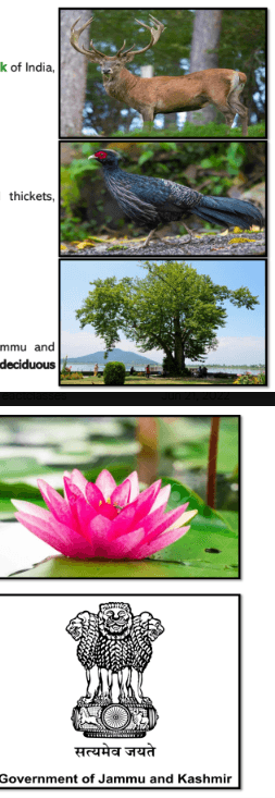
| UT Animal | Hangul (Kashmiri Stag) | Zoological name: Cervus elaphus hanglu; subspecies of elk (deer family); IUCN status: Critically Endangered; mainly found in Dachigam National Park, Srinagar |
| UT Bird | Kalij Pheasant | Zoological name: Lophura leucomelanos; local names: Kokur (Kashmiri), Van Kokad (South Kashmir); declared UT bird on 21 October 2021; IUCN status: Least Concern; found in hilly areas like Kishtwar and extends through Himalayas to Thailand |
| UT Tree | Chinar | Botanical name: Platanus orientalis; called "Boon" in Kashmiri; deciduous (sheds leaves in autumn); known for longevity (centuries old) and wide spreading canopy |
| UT Flower | Lotus | Symbolizes purity, beauty, majesty, grace, fertility, wealth, knowledge |
| UT Emblem | None (officially) | J&K currently uses the National Emblem of India (Ashoka Pillar with "Government of Jammu and Kashmir" written below). The earlier State Emblem has been abolished. |
🎯 PYQ ⭐ — Website-Operator 2026 · Q38
Which J&K species are critically endangered? (Hangul, Snow Leopard, Himalayan Tahr, Markhor) → ✅ Hangul & Markhor (per official key). The Hangul (UT animal) is the surest repeat.
3. Location — Latitude & Longitude
- Latitudes = horizontal imaginary lines (measure N–S position); Equator = 0°
- Longitudes = vertical imaginary lines (measure E–W position); Prime Meridian = 0°
- India lies above the equator → Northern Hemisphere → all latitudes here are "North"
- Refer to the earlier GK of India (Geography) video for a detailed explanation if this is unclear.
Latitudinal Extent (Horizontal lines)
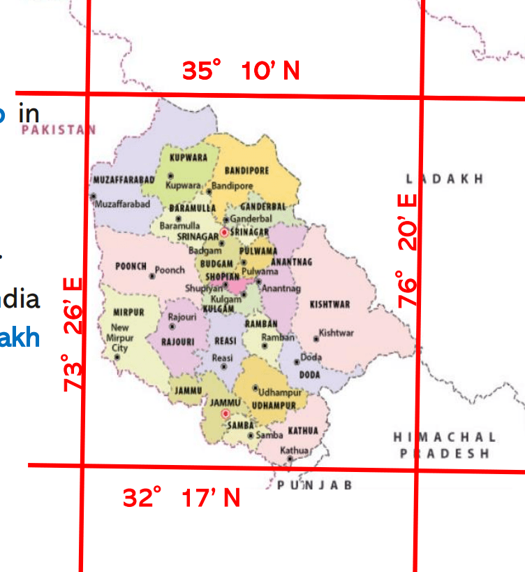
- Northernmost point: near Muzaffarabad → 35°17′10″ N
- Southernmost point: → 32°17′ N
- ➡️ Latitudinal extent: 32°17′ N to 35°17′10″ N
Longitudinal Extent (Vertical lines)
- Westernmost point: → 73°26′ E
- Easternmost point: → 76°20′ E
- ➡️ Longitudinal extent: 73°26′ E to 76°20′ E
4. Boundaries
Internal (State/UT) Boundaries
- South: Punjab
- South-East: Himachal Pradesh
- North & East: Ladakh
International Boundary
- Shares border with only one country: Pakistan (via the international border and the Line of Control – LoC)
- Ladakh (for comparison) shares borders with Pakistan, Afghanistan, and China
Areas across LoC (under Pakistan control, historically part of J&K)
- Muzaffarabad district
- Mirpur district
- Small part of Poonch district
- Largest UT by area: Ladakh (~59,000 sq km, area under India's control)
- Largest UT by population: Delhi
- J&K is the 2nd largest UT both by area and by population
5. What is Physiography? (Concept)
Just like India has physiographic divisions (Himalayas, Northern Plains, Western/Eastern Ghats, Coastal Plains), J&K (including Ladakh) also has its own physiographic divisions.
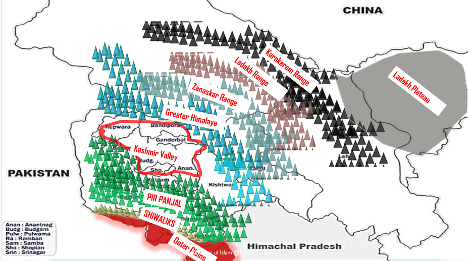
The 7 Broad Physiographic Divisions of J&K (as taught in this lecture)
- Outer Plains
- Foothills / Shivaliks
- Pir Panjal Range (Lesser/Middle Himalayas)
- Valley of Kashmir
- Greater Himalayas
- Karakoram Region
- Ladakh Plateau
6. Outer Plains
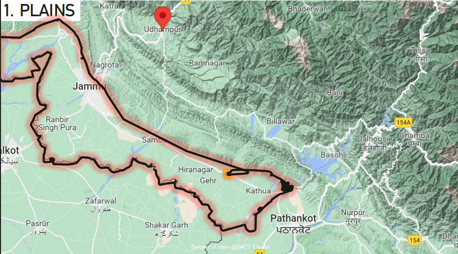
- Extension of the Great Indian Northern Plains
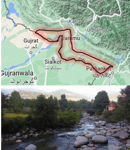
- Formed by erosion & deposition of sediments brought by rivers (Ravi, Tawi, Chenab, Basantar, Ujh, etc.)
- Located in: southern Kathua, Samba, and Jammu regions
- Local names: "Andarwah" and "Bajwat" (important — asked in JKPSC/JKSSB exams)
- The term "Bajwat" is also used in bordering Pakistani regions like Sialkot
Special Features of Outer Plains
| Feature | Description |
|---|---|
| Ravines (Khadd) | Hill streams/torrents flowing from Shivaliks into the plains; dry most of the year, filled only during monsoon |
| Khar | A type of elephant grass grown in outer plains; used to make brooms |
| RS Pura Sector | Most fertile region of the Outer Plains; major agricultural belt |
 | |
 |
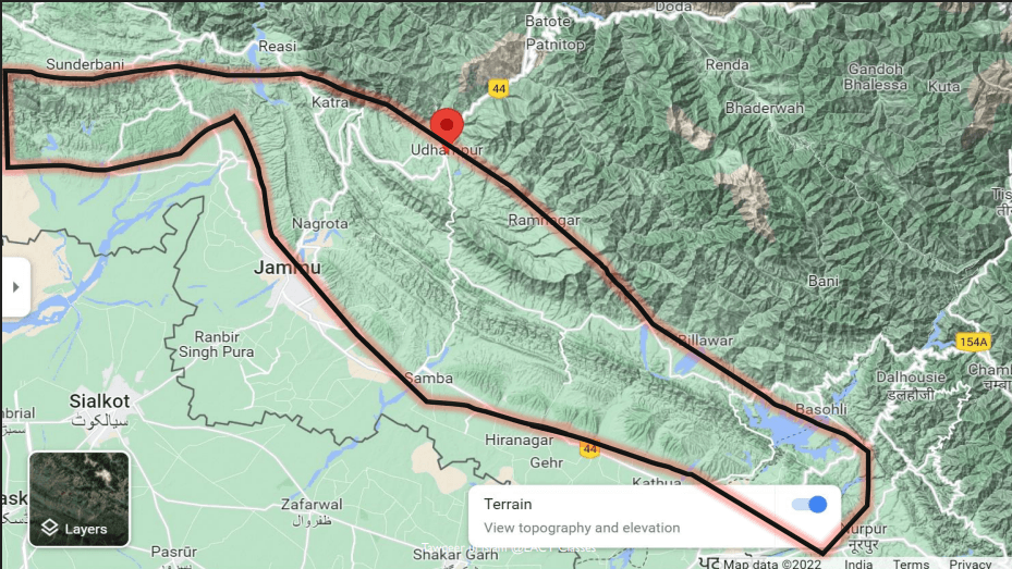
7. Foothills / Shiwaliks
- Also called Outer Himalayas
- Made of young Tertiary rocks (youngest rock type — formed last during Himalayan formation)
- Formation order: Karakoram → Greater Himalayas → Middle Himalayas → Shivaliks (last)
- Width: 20–50 km (varies)
- Average elevation: 600–1200 m
- Extends from Kathua to Rajouri (approx.)
- Ancient name: Manak Parbat
- Formed due to collision of Indian Plate with Eurasian Plate (folding of land, like folds formed when pushing a cloth/paper)
Important Features
| Term | Meaning |
|---|---|
| Dhun/Duns | Longitudinal valleys formed by erosion, found between Shivalik ridges. Examples: Udhampur Valley, Basoli, Kotli |
| Undulating slopes | Wave-like rise-and-fall pattern of land in inner Shivalik zone |
| Kandi Belt | Region with undulating slopes, located between Ravi and Chenab rivers; economically backward, home to the Dhudhiya Gurjar community (pastoralists who sell milk) |
🎯 PYQ — Junior-Assistant 2026 · Q57
Geography of the Jammu region — which is correct? → ✅ Jammu city sits on uneven Shivalik ridges (Statement I). ⚠️ "Jammu is surrounded by the Ladakh range" is wrong — that was the trap statement.
8. Pir Panjal Range (Lesser / Middle Himalayas)
- Also called Lesser Himalayas / Middle Himalayas
- Made of volcanic (primary) rocks — granite, gneiss, quartz, etc.
- Average elevation: 3600–4600 m
- Extends from Ravi River area up to Baramulla — longest range within J&K
- Also the westernmost range within J&K
- In Jammu region, locally called simply "Pahad"
- Pir Panjal Range (main one covered)
- Dhauladhar Range (extends into Himachal Pradesh)
Important Rivers Originating Here
Tawi, Manwar Tawi, Basantar, Ujh
Important Peaks & Passes in Pir Panjal
| Feature | Location/Detail |
|---|---|
| Sunset Peak | Between Poonch & Shopian; ~5200 m; named because sun sets behind it as seen from South Kashmir |
| Haji Pir Pass | Between Poonch and Uri |
| Pir Panjal Pass (a.k.a. Peer Ki Gali) | On Mughal Road, between Shopian and Poonch |
| Banihal Pass | Near Banihal |
| Sinthan Pass | Between Anantnag and Kishtwar |
| Jawahar Tunnel | Connects Banihal–Qazigund; built in 1956 |
| Banihal-Qazigund Rail Tunnel | New tunnel, runs below Jawahar Tunnel; 8.45 km |
| Atal Tunnel | Between Leh–Manali, under Rohtang Pass; 8.8 km; 2nd longest road tunnel in India |
| Shyama Prasad Mukherjee Tunnel | Connects Ramban & Udhampur; longest road tunnel in India |
| Trikuta Hills | Location of Vaishno Devi Cave (Katra) — part of Pir Panjal |
| Gulmarg | Located within Pir Panjal |
- The 8.45 km Banihal–Qazigund tunnel is a ROAD tunnel (opened 2021), not a rail tunnel. The railway tunnel here is the Pir Panjal (Banihal) Railway Tunnel ≈ 11.2 km — India's longest rail tunnel for years. Don't label the 8.45 km one as "rail".
- Atal Tunnel ≈ 9.02 km (not 8.8 km); it connects Manali (Solang) ↔ Lahaul (Sissu) under Rohtang — "Leh–Manali" is loose.
🎯 PYQ ⭐ — Guard-FPF 2026 · Q111
Arrange the passes West → East: Hajipir, Sach, Banihal → ✅ Hajipir → Banihal → Sach (I-III-II).
🎯 PYQ — Guard-FPF 2026 · Q112
Which are peaks of the Pir Panjal at its eastern end? (Deo Tibba, Indrasan) → ✅ Both.
🎯 PYQ ⭐ — Social-Forestry 2026 · Q112
Travelling Jammu → Srinagar by road, you cross which pass? → ✅ Banihal Pass (Jawahar Tunnel) — not Fotu La / Bara Lacha La / Rohtang.
🎯 PYQ — Website-Operator 2026 · Q40
The Sadhna Pass is in which district? → ✅ Kupwara (Sadhna/Nastachun Pass, Karnah–Tangdhar). ⚠️ This pass isn't in the tables above — add it to your passes list.
9. Valley of Kashmir
🎯 PYQ ⭐ — Website-Operator 2026 · Q39
The Kashmir Valley is bounded on the SW by the ___ Range and on the NE by the ___ Range. → ✅ SW = Pir Panjal, NE = Great Himalayas.
Formation Story (Important — Satisar Lake Theory)
- The valley was once a huge lake called Satisar (~1 million years ago, Pleistocene period)
- Due to tectonic activity, a gorge formed at Baramulla in the Pir Panjal range
- Water gradually drained out through this gorge
- As water drained, the lake bed became exposed, leaving behind sediment deposits
- These deposits are known today as Karewas
- Later, the Jhelum River formed, flowing through the middle and exiting via Baramulla
Physiographic Divisions within Kashmir Valley
| Division | Description |
|---|---|
| Valley Floor | Lowest, flat plain area along the Jhelum River |
| Karewas (Wudar) | Elevated, flat-topped tablelands; lacustrine deposits (deposits of a lake); term coined by geographer Godwin Austin (also K2 is named after him); made of loamy soil; Saffron is cultivated here, especially in Pampore; also found in Bhadarwah Valley (Jammu) |
| Side Valleys | Smaller valleys formed by erosion from tributary rivers, e.g., Lidder Valley, Sindh Valley |
- Found mostly on the LEFT bank of Jhelum → Shopian, Kulgam, Pulwama, Budgam (Khan Sahib area)
- Side valleys are found mostly on the RIGHT bank of Jhelum → because major tributaries (Sindh, Lidder) join from the right side
10. Greater Himalayas
- Lies north of Pir Panjal, on the northern boundary of Kashmir Valley
- Average elevation: 4500–7100 m
- Acts as a climatic barrier — blocks cold winds from Central Asia/Siberia/Tibetan Plateau from entering India (crucial for India's climate & population)
- Zanskar Range is a part of the Greater Himalayas (lies just north of it)
Important Peaks
| Peak | Detail |
|---|---|
| Nanga Parbat | Located in Gilgit-Baltistan; 9th highest peak in the world; lies southeast of the northernmost bend of Indus River; also called Diamer/Diamir or "King of Mountains"; westernmost major peak of Greater Himalayas |
| Nun Peak | Highest peak in J&K (UT); located in the Zanskar Range; ~7000 m; on J&K side of J&K-Ladakh border |
| Kun Peak | On the Ladakh side of the border; also in Zanskar Range |
| Pinnacle Peak | Third peak alongside Nun & Kun |
- Nun Peak → in J&K, highest peak of J&K, part of Zanskar Range
- Kun Peak → in Ladakh
- Both lie in the Zanskar Range
11. Zanskar Range
- A part of the Greater Himalayas (name changes locally because the region is called "Zanskar")
- Separates Zanskar/Kargil region from Ladakh
- Contains Nun and Kun peaks
- Important passes: Marbal Pass, Zojila Pass, Fotula Pass, Namikala Pass, Pensila Pass
- Zojila Pass connects Srinagar (Kashmir) to Leh/Kargil
12. Ladakh Range
- A part of the Karakoram Range (NOT Greater Himalayas)
- Lies north of Zanskar Range
- Between Zanskar and Ladakh Range lies the Leh-Kargil Valley, also called the Upper Indus Valley (since Leh sits on the banks of the Indus)
- Starts where the Indus River meets the Shyok River, descends toward the Tibet border
- Important passes: Chorbat La, Digar La, Khardung La, Chang La, Umling La, Saser La
- Zanskar Range → part of Greater Himalayas
- Ladakh Range → part of Karakoram Range
13. Karakoram Range
- Word "Kara" = Turkish for black; these were ancient volcanic mountains
- Starts from the Wakhan Corridor (northernmost point of J&K, bordering Afghanistan)
- Passes through Gilgit-Baltistan and descends into the Aksai Chin region of Ladakh
- Also called: Mount Godwin Austin (named after geographer Godwin Austin)
K2 & Peaks
- K2 (Mount Godwin Austin) = 2nd highest peak in the world; also called Chhogori or "Savage Mountain" / "Crest of the World"; located in Gilgit-Baltistan
- Karakoram has 18 peaks above 7500 m, of which 4 are above 8000 m (called "Eight-thousanders")
- Other notable peaks: Gasherbrum, Masherbrum, Broad Peak
Pamir Knot
- Karakoram
- Himalayas
- Hindu Kush (Afghanistan side)
- Kunlun Mountains (Chinese side)
Also called the "Roof of the World". Forms a plateau region.
Important Passes
Karakoram Pass, Nubra Pass — historically used by Ladakhi people to trade with Chinese Turkestan
14. Ladakh Plateau
- Flat/plateau region, located after crossing Karakoram
- Aksai Chin — part currently under Chinese control (India controls the western part)
- Contains multiple plains:
| Plain | Notes |
|---|---|
| Depsang Plains | Also known militarily as "Sub-Sector North" |
| Lingzhi Tang Plains | Falls on the Chinese side (Aksai Chin) |
| Murree/Chushul Plains | Located on the Leh-Manali Highway; also called Qingchu Tang |
15. Important Mountains & Peaks — Quick Reference Table
| Mountain/Peak | District/Location | Key Fact |
|---|---|---|
| Kolahai Mountain (Glacier) | Anantnag | Source of Lidder River |
| Haramukh Mountain | Ganderbal | Lies between Sindh Nallah & Neelum (Kishanganga) River; Gangbal Lake at its foot; associated with Kashmiri Pandit worship of Lord Shiva |
| Burzil Mountain/Pass | Between Kupwara & Gilgit-Baltistan | Historic route from Kashmir to Skardu/Gilgit-Baltistan; separates Kashmir & Ladakh; near Deosai National Park |
| Afarwat Mountain | Gulmarg, Baramulla | Reached via Gondola; Alpather Lake (a.k.a. Frozen Lake / Wari Kanol Nag) at top; feeds Nalanag stream → Wular Lake; part of Pir Panjal |
| Nun & Kun Peaks | Kishtwar/border of J&K-Ladakh | Nun = highest peak of J&K; both in Zanskar Range |
| Amarnath Peak | Ganderbal | Holy Cave of Hindus; reached via Pahalgam or Sonamarg; nearby Mahagunas Pass; Sheeshnag Lake en route; source river: Lidder (from Kolahai Glacier) — lies in Greater Himalayas |
| Nanga Parbat | Gilgit-Baltistan | 9th highest peak in the world |
| Tosa Maidan | Budgam | Meadow + mountain range in Inner Himalayas (Pir Panjal); former military firing range (closed after unexploded shell incidents); passes: Poonch Gali, Basmai Gali |
| Soyamji Mountain | Handwara (Kupwara) | Dormant volcano; erupted for 13 months in 1934, inactive since |
| Khareva Mountain Peak | Pahalgam | Dead/extinct volcano |
🔑 Quick Revision Pointers / Short Reminders
Rapid Recall Checklist
- UT formed: 31 Oct 2019 | Area: 42,000 sq km | Population: 1.2 crore | Density: 290/sq km
- 20 districts (10+10) | 5 official languages: Urdu, English, Dogri, Hindi, Kashmiri (Bill passed Sep 2020)
- UT Animal: Hangul (Critically Endangered) | UT Bird: Kalij Pheasant (Least Concern, declared 21 Oct 2021) | UT Tree: Chinar ("Boon") | UT Flower: Lotus | UT Emblem: None — uses National Emblem
- Latitude: 32°17′N – 35°17′10″N | Longitude: 73°26′E – 76°20′E
- Borders: Punjab, Himachal Pradesh, Ladakh (internal); Pakistan (international, only 1 country)
- 2nd largest UT by area & population (Ladakh is largest by area, Delhi by population)
- Order of physiographic divisions (south → north): Outer Plains → Shivaliks (Foothills) → Pir Panjal (Lesser Himalayas) → Valley of Kashmir → Greater Himalayas → Zanskar Range → Ladakh Range → Karakoram Range → Ladakh Plateau
- Outer Plains local names: Andarwah, Bajwat | Special features: Ravines/Khadd (seasonal), Khar (elephant grass for brooms)
- Shivaliks: youngest (Tertiary) rocks | 600–1200 m | Contains Dhuns (Udhampur, Basoli) and Kandi Belt (Dhudhiya Gurjars)
- Pir Panjal: volcanic rocks | 3600–4600 m | Longest & westernmost range in J&K | Key passes: Banihal, Sinthan, Haji Pir, Peer Ki Gali
- Karewas = lacustrine deposits, coined by Godwin Austin; saffron grown at Pampore; mostly on left bank of Jhelum
- Kashmir Valley formed from ancient Satisar Lake → gorge formed at Baramulla → water drained → Karewas left behind
- Zanskar Range = part of Greater Himalayas; has Nun (highest peak of J&K) & Kun peaks
- Ladakh Range = part of Karakoram Range
- Karakoram = "Kara" (Turkish) = black; contains K2 (2nd highest peak in world, a.k.a. Godwin Austin/Chhogori/Savage Mountain)
- Pamir Knot = meeting point of Karakoram, Himalayas, Hindu Kush, Kunlun — called "Roof of the World"
- Ladakh Plateau has Depsang Plains (Sub-Sector North), Lingzhi Tang Plains (China side), Chushul/Murree Plains
- 2 extinct/dormant volcanoes in J&K: Soyamji (Handwara) – dormant, erupted 1934; Khareva (Pahalgam) – dead
📌 Tags for linking
#Karewa #Shivalik #PirPanjal #Zanskar #Karakoram #LadakhPlateau #ValleyOfKashmir #UTsymbols
